
 |
| And through the jungle mists, I spy the Great Lost Pyramid of Tazumal. Located in an outer suburb of San Salvador. |
What's on today's agenda? Pyramids, pyramids, and pyramids. These are the pre-Mayan and Mayan-era pyramids in the environs of San Salvador. Admittedly, these pyramids are not as spectacular as Copan. These pyramids are smaller and have suffered greatly from earthquakes and volcanos. And that means that the archaeology is a lot more in the early stages and what can be seen is more re-creation than restoration.
First stop: Joya de Cerén.

Let's have a look-see.

This is called the "Pompeii of the Americas." And that's legitimate. It is a very well-preserved small Mayan village from the early classical period. Which got buried for several centuries under a huge amount of volcanic ash. This meant much of the village is well-preserved.


Unlike Pompeii, there were no dead bodies. This is because, apparently, the residents of Joya de Cerén had the foresight to bug out at the signs of the volcanic activity. They were not taken by surprise like the villagers in ancient Pompeii.

They did not climb that ladder when they were getting the h*ll out of Dodge, or, in this case, Joya de Cerén. Two reasons. First of all, they didn't have metal ladders. This is from the archaeologist. But, more importantly, until their city was buried in a few dozen feet of volcanic ash, they would not have had to climb out of the hole to get away.

Below is the functional equivalent of City Hall.

The buildings do not have roofs because the roofs were made of thatch and (Thatch) + (Volcanic Explosion) = (No More Thatch), in simple mathematical terms.


There is a Mayan sauna in this picture. From the description, it seems less like a Finnish sauna than the sweat lodges used by the indigenous people of the Southwestern United States.


Finally, we end our visit to Joya de Cerén with this:

Again, that's an animal we don't usually see in Mayan iconography. It looks like a camelid. Maybe a llama. Or a guanaco. Apparently people in other Central American countries call Salvadoreans "Guanacos." It's what we would call a friendly insult. Equal parts each. Did those wise Mayans of yesteryear foresee a future when the inhabitants of this land would be called "guanacos"? The wonder of the ancient Maya.
Moving on to the next stop, which actually does feature real pyramids (which are largely still buried under the volcanic soil): Parque Arqueológico San Andrés.


The opening below on this ancient ruin was for the archaeologists, but it's not been sealed shut.


Damn. Who is the decrepit old guy who keeps jumping in front of me when someone is taking a picture of the young and handsome me? This ancient ruin is so girthy that you cannot even see me with him standing in front of me like that.


The Mayans figured out how to extract indigo dye from this decidedly not-blue plant. It's a complicated three-stage process. Indigo was beloved by the Europeans soon after the Spanish made contact with the New World. And they hadn't even invented Levi's blue jeans yet. The indigenous Mayans worked in slave conditions to produce the huge amount of indigo Europe was demanding which, let's just say, was a whole lot more than the indigo needed to blue-up a small Mayan village. Eventually, African slaves were brought in to work in the indigo mills after the Spaniards -- pretty much literally -- worked the Maya to death in the indigo factories.
And speaking of local plants whose wealth was also not obvious and, yet, the Mayans figured out the complicated to extract something from this plant that became tremendously valuable after the Spanish contact with the New World:

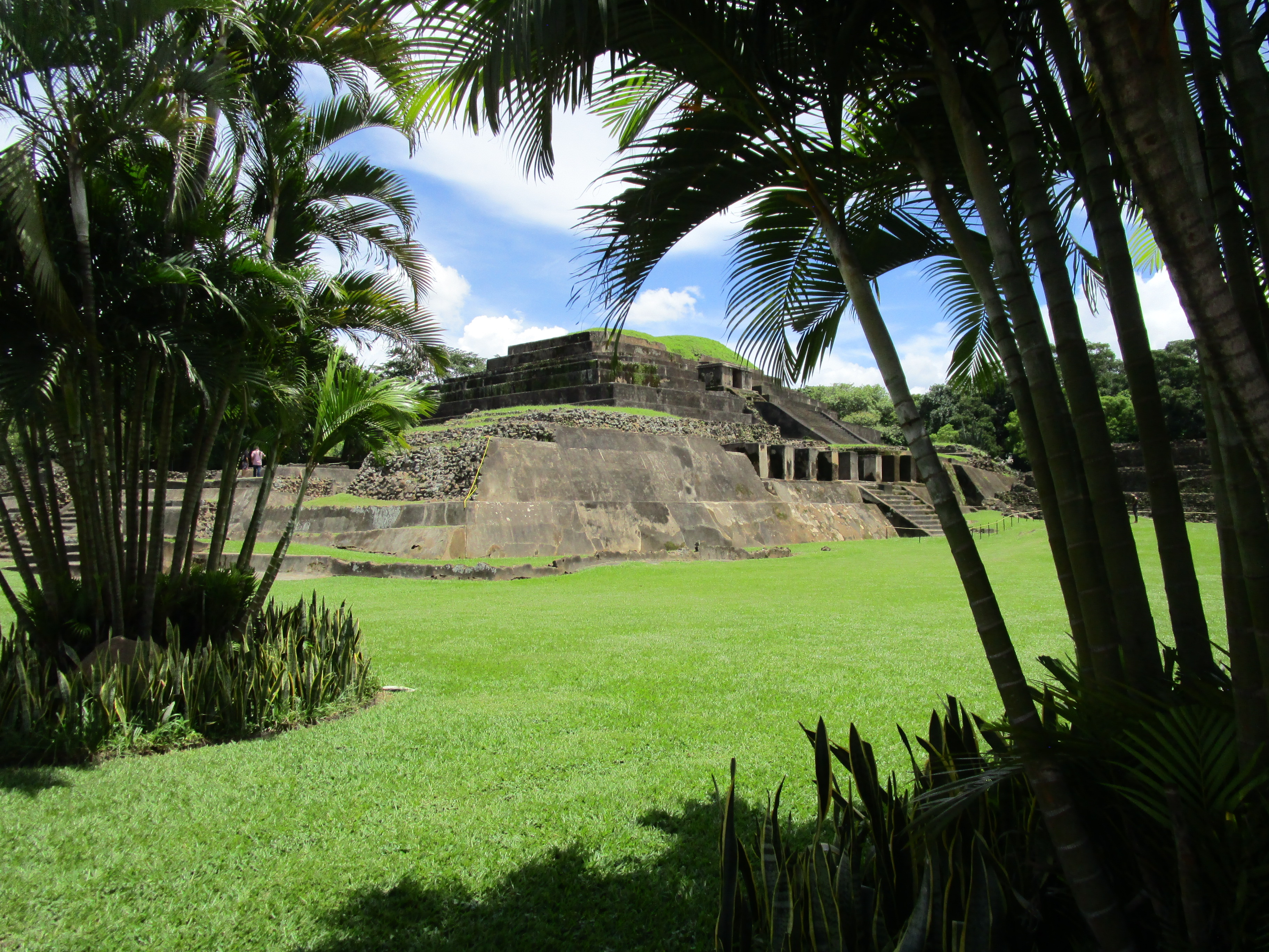
Next stop: Tazumal.

This is not a historic site for quiet contemplation.

And here's the star of the Tazumal show:


And looking from a different angle:


And visible next to Tazumal was one of the more colorful cemeteries I have ever seen.


And that will conclude the pyramid portion of this five-day holiday vacation weekend. It's on to the beautiful colonial era town of Santa Ana.

We didn't stop long in Santa Ana. Just enough time on the way to lunch by the lake to snap a few pictures.

This is the Teatro de Santa Ana.


This is the former casino, catty-corner from the main plaza. Yes, it's "catty-corner." It's not "kitty-corner" or some other such nonsense. Catty. Corner. Hyphenated.


This is the Cathedral of Santa Ana.

The interior is nice:

But the exterior is what makes this spectacular.

And here is a picture of me in front of the cathedral. The tour guide who snapped the picture thought the picture was ruined because several birds took off and flew in front of me when the picture was snapped.

I really don't like pictures of me much at all. But I think this particular picture is all kinds of awesome. You can tell I'm worried about whether Suzanne Pleshette is going to get all of her schoolchildren to safety before the birds attack. (Obscure Hitchcock reference. The best kind of Hitchcock reference.)
One last look at Santa Ana

Lunch time!


I had a beef dish, with tortillas, carrots, a small bit of corn, avocado, chorizo and a mixture of rice and refried beans called "casamiento," which translates to "marriage," which is a typical Salvadorean style of serving rice and refrieds.

Dessert was coffee and a cake made from rice flour and cheese.

And that ends today's excursion. No supper blogging tonight because this was a late lunch and -- more importantly -- did you see how much food was on my lunch plate?
No comments:
Post a Comment